


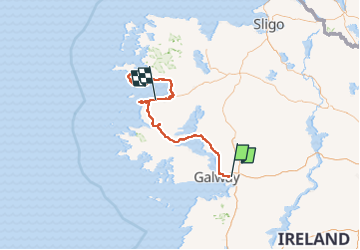
J N°3 LUNDI GALWAY 2 NUITS A WESPORT

rousseau.mich
Benutzer

Länge
291 km

Maximale Höhe
87 m

Positive Höhendifferenz
2750 m
Km-Effort
328 km

Min. Höhe
-2 m

Negative Höhendifferenz
2750 m
Boucle
Nein
Erstellungsdatum :
2023-11-21 10:53:34.241
Letzte Änderung :
2024-05-07 19:18:29.883
4h00
Schwierigkeit : Sehr leicht

Kostenlosegpshiking-Anwendung
 SityTrail
IGN / Geografische Institute
SityTrail Plus
Die Welt öffnet sich für Sie
Über SityTrail
Tour Motorrad von 291 km verfügbar auf Unbekannt, County Galway, Athenry-Oranmore Municipal District. Diese Tour wird von rousseau.mich vorgeschlagen.

Ort
Land:
Ireland
Region :
Unbekannt
Abteilung/Provinz :
County Galway
Kommune :
Athenry-Oranmore Municipal District
Standort:
Oranmore ED
Gehen Sie:(Dec)
Gehen Sie:(UTM)
507305 ; 5903139 (29U) N.
Kommentare